

One Subscription.
Built for the Entire Project Lifecycle
Replace disconnected tools with a single system that supports data collection, project management, laboratory workflows, and reporting from start to finish
5M
Forms created
25
Countries
16
Languages
12+
Years of experience
Testimonials

Josh Calkin
Principal Engineer
ERM
"Decreased time in the field and time in the office due to a streamlined data capture, QA/QC, and reporting process. The added features of the app have been an important tool for much of our fieldwork. For instance, the ability to capture an aerial view and check the surroundings of the sites has allowed us to find issues in the field that we would not have observed on our own."

Nader Sherif
Vice President
Terraphase Engineering
"I like being able to see what is happening in the field in real time. I like having a professional looking field sheet that i can incorporate into my reports without additional effort. I like having digital data that can be incorporated into the database without additional QC efforts. I like that the program saves us time and money."

Rati Mandzulashvili
Senior Geotechnical Engineer
Haley and Aldrich
"I assisted a fellow Project Manager in gathering data in the field. QNOPY was a game-changer. It did a great job of standardizing each site audit and recording the necessary data all in one place. I was very impressed."

Complete data management for Environmental & Geotechnical Projects
Field data | Lab data | GIS | Reports
Plan, collect, manage, and report on environmental project data, all in one platform.







Field Data Collection, Groundwater Monitoring, Lab Data Management, Soil Studio & GIS Mapping Software
Plan, manage, and streamline any type of fieldwork with QNOPY’s field data collection app. Simplify groundwater sampling and monitoring, create soil boring logs and 3D subsurface visualizations with Soil Studio, and analyze project data with integrated GIS mapping tools—all in one connected platform.
Field Data Collection App
Mobile app available on both IOS and Android platforms that works fully offline.
Same app for every type of field work: sampling, EHS, soil, asbestos, wetlands, and many more
Features like speech-to-form, scanning meters, automated stabilization, map-based navigation, photos and drawings
Multiple people can record data for the same location simultaneosly
Completely customized field logs, eCOCs, boring logs, photo logs, and 3D cross sections

GIS Mapping
Built-In GIS Mapping helps to create, visualize, and share interactive maps directly within the platform.
Plot sample locations, site boundaries, and field activity on interactive maps in real time
Overlay environmental data and survey results to identify patterns and make faster decisions
Share maps with your team or clients with role-based access control
Produce report figures with data boxes, groundwater elevation contours, and heat maps

Lab Data Management. No Training Needed
Centralized Lab Data Management lets you upload, organize, and securely store all your laboratory data in one central database and makes it available on the web portal.
Sample planning module to plan your sampling event
Automated laboratory data upload with a simple EDD that any labs can provide
Valid values to maintain data quality
Screening criteria: choose from pre-loaded criteria or upload your own criterias
View and export lab data: report tables, cross tabs, and time series charts

Advanced Soil Logs & Cross Sections
Generate report-ready soil logs and cross sections quickly and accurately
Log soil descriptions, classifications, and field observations directly from any device in the field
Paper-like mobile app interface to record boring logs in the field
Easily create boring log templates with drag and drop template builder
Automatically generate formatted boring logs and 3D cross sections from collected data

Managed Implementation Services
We help you implement your field data digitization with a team that has over 12+ years of experience helping environmental and geotechnical companies.
We build your forms, we train your teams, and we manage your data
We provide 24/7 support over email/phone to make sure your field work flows smoothly
We are your technology partners. We take care of all the technology so you can focus on your business


Build forms with AI or drag-and-drop tools
Testimonials

Jeff Woodward
Senior Construction Program Manager
Jacobs
"Our team at JACOBS is using the QNOPY app on a major Interstate project for GDOT and could not be happier with the results. Definitely recommended.
The QNOPY application dramatically improved our speed and accuracy in completing our pavement rating evaluation for our client. The application was easily customizable and QNOPY provided great customer service and the technical expertise to ensure our needs were met."

Nader Sherif
Vice President
Terraphase Engineering
"I like being able to see what is happening in the field in real time. I like having a professional looking field sheet that I can incorporate into my reports without additional effort. I like having digital data that can be incorporated into the database without additional QC efforts. I like that the program saves us time and money."

Josh Calkin
Principal Engineer
ERM
"Decreased time in the field and time in the office due to a streamlined data capture, QA/QC, and reporting process. The added features of the app have been an important tool for much of our fieldwork. For instance, the ability to capture an aerial view and check the surroundings of the sites has allowed us to find issues in the field that we would not have observed on our own."

Rati Mandzulashvili
Senior Geotechnical Engineer
Haley and Aldrich
"I assisted a fellow Project Manager in gathering data in the field. QNOPY was a game-changer. It did a great job of standardizing each site audit and recording the necessary data all in one place. I was very impressed."
Kenneth Ruiz
Project Manager
ERM
"It's paperless and cloud based. Really like the options for different format outputs (pdf, word, and excel)."
Latest QNOPY Features
Capture, organize, and summarize field data automatically so your team can spend less time typing and more time getting work done

Speech to Form
Turn spoken notes into structured field data instantly. Just talk; QNOPY’s AI speech captures your observations, measurements, and site conditions hands-free, so you never have to stop working to type.

Scribe
Say goodbye to manual data entry. AI Scribe watches as you fill out forms and intelligently suggests entries, auto completes repetitive fields, and learns your patterns; cutting form completion time in half.

Event Summary
Transform raw field data into clear, client-ready narratives automatically. AI Event Summary pulls from your logs, photos, and form entries to generate professional summaries you can review and send. No more writing reports from scratch at the end of the day.

QNOPY is a connected environmental data management platform that simplifies field collection, laboratory workflows, GIS mapping, project management, and reporting - all in one secure system.
Solutions
©2026 QNOPY All rights reserved
Success Stories
Proven Results in the Field


Groundwater Sampling
CASE STUDIES
A global consulting firm ditched paper logs for QNOPY's offline mobile app, tracking 1,000+ groundwater wells per quarter across California's Mojave Desert.
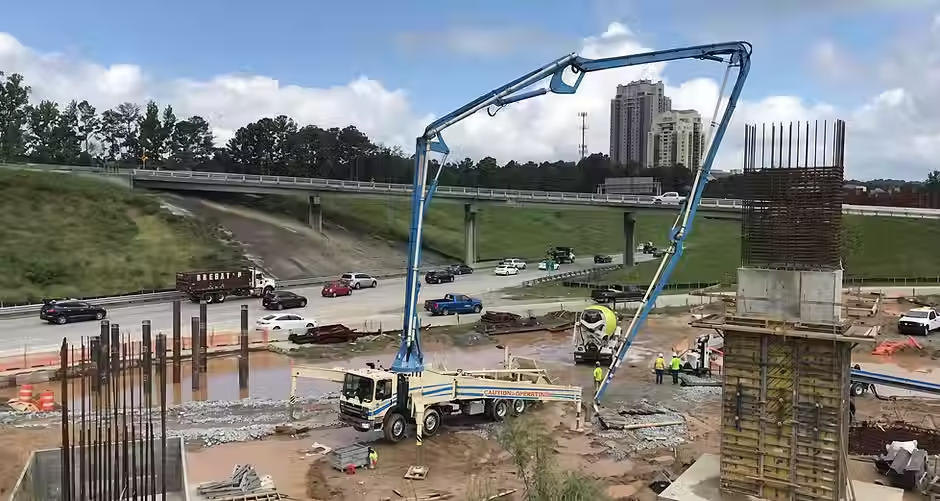
Photo Log
CASE STUDIES
QNOPY brought order to a five-year Georgia highway project by capturing and organizing 20,000+ GPS-geotagged, timestamped field photos in one place.

Inspection Reports
CASE STUDIES
An environmental firm ran faster oil and gas well assessments with QNOPY, deploying multiple inspectors simultaneously using pre-filled data, satellite maps, and field photo attachments.

EHS Audits
CASE STUDIES
QNOPY's EHS Audit app let construction field teams log unsafe behaviors on the spot, score contractor conduct, and take immediate corrective action, building a measurable safety culture.


Streamline and Enhance your Field Data Collection
Our mobile app for field data collection is intuitive and fast, making fieldwork efficient and enjoyable. With a sleek, user-friendly interface packed with useful features, your field team will be quick to adopt a digital workflow.
Feature-Rich Platform Tailored for Environmental Experts
Custom Field Interface :
Build your mobile field data collection app exactly how you want it. Place drop downs, checkboxes, pre-poluated fields, reminders, and more!
GIS Mapping Integration :
View and mark field points or wells directly on a map, even offline. Capture and adjust GPS coordinates easily with simple map interactions.
Dynamic Dashboards and Reporting:
Access a variety of customized and standard dashboards to view and analyze your data effectively. Generate tailored reports in formats you need - Word, Excel, or PDF.
Photo Capture and Annotation :
Take detailed photos and annotate them directly in the app to add context to your data.

Every part of your field workflow, simplified
Built for the way environmental and industrial teams actually work offline, in the field, under pressure, and on tight deadlines

AI Form Builder
Describe your field protocol in plain language. AI generates a fully compliant, mobile-ready form in seconds complete with smart logic, skip conditions, and required fields pre-configured.

Real-Time Data Validation
AI flags anomalies, missing values, and out-of-range readings while your team is still in the field before you pack up the equipment.

Auto-Generated Reports
From onboarding to downtime, switching tools often comes with more cost than expected.

True Offline Mode
Full functionality without cell service. Data syncs the moment connectivity returns. No forms lost, no duplicates, no manual reconciliation.

Site Mapping & GIS
Tie every data point to a precise GPS location. Visualize site coverage, track sampling progress, and export to your GIS stack instantly.

Lab & LIMS Integration
Send field data directly to your lab system. Eliminate manual data entry, reduce CoC errors, and get lab results linked back to the original sample automatically.
Step - 1
Field Teams
Capture accurate field data with mobile forms, GPS, photos, and offline access without paperwork or duplicate entry.
Step - 2
Laboratory Teams
Manage samples, track results, and generate figures from a centralized system built for environmental workflows.
Step - 3
Engineers & Project Managers
Review data, approve deliverables, and create reports faster using standardized workflows and integrated project information.
Step - 4
Owners & Operations
Gain visibility across projects, teams, and deliverables to improve accountability, efficiency, and client outcomes.